Top 7 GPS Apps for Farm Activity Tracking
Managing farm activities is now easier with GPS apps. These tools help farmers track equipment, plan tasks, and monitor fieldwork with precision. From reducing overlaps during planting to logging costs and compliance data, these apps improve efficiency and save resources. Here's a quick rundown of the top GPS apps for farm activity tracking:
- HarvestYield: Tracks jobs, machine costs, and weather; free up to 50 acres, with paid plans from $49/month.
- OneSoil Scouting: Uses satellite imagery and AI for crop monitoring; free with optional upgrades.
- Tractor GPS – Field Guidance: Offers simple navigation and offline use; free basic version.
- Precision Tracking (Farmonaut): Satellite-based crop health tracking; starts at $19/month.
- Farm Equipment GPS Tracking: Focused on fleet and equipment navigation; paid plans available.
- fieldmargin: Combines GPS field notes with team collaboration; starts at $13.49/month.
- FarmQA: Designed for scouting and compliance with offline syncing; free basic tier.
Each app caters to specific farming needs, from machine guidance to crop scouting. For large teams, HarvestYield offers robust tools, while OneSoil Scouting is ideal for smaller farms looking for cost-effective solutions. Whether tracking tasks, managing costs, or improving yields, there's an app for every farm size and goal.
Webinar: Learn how to use a free GPS tracking app for precision farming
Key Features To Look For In GPS Farm Activity Apps
When picking a GPS farm app for U.S. fieldwork, focus on tools that align with the practical needs of daily operations. Features like accurate mapping, offline capabilities, and cost tracking can make a big difference.
Precise field mapping is a game-changer. Apps with AB line guidance and real-time visual coverage maps help avoid overlaps and missed spots during tasks like seeding or spraying. This not only saves on inputs like seeds and chemicals but also cuts down on fuel usage. For U.S. farms, ensure the app uses acres, miles, and feet for measurements and reports temperatures in °F, so it fits seamlessly with your workflow.
Offline functionality is non-negotiable. Rural areas often lack reliable cellular coverage, and an app that depends on a signal can leave you stranded. Look for options that save data locally and sync automatically when you're back online. That way, your work won’t grind to a halt if you lose service.
Cost and job tracking features elevate basic GPS tools into full-fledged farm management solutions. The ability to log field boundaries, task durations, start and end times, and client details is invaluable. Even better, apps that track machine costs - like fuel consumption, maintenance schedules, and repair expenses - help you calculate the true cost of each job. This data is crucial for improving seasonal profitability. In fact, mapping software can improve yield tracking accuracy by up to 40% compared to manual methods.
Some advanced apps go even further by incorporating environmental data. Features like weather logging, rainfall tracking, and pest observation recording allow you to build a detailed field history. This can be essential for compliance, insurance claims, or organic certification audits. Finally, check for platform compatibility - does the app work on both iOS and Android? Can it integrate with the equipment systems you’re already using? These details ensure the app fits smoothly into your operation.
1. HarvestYield
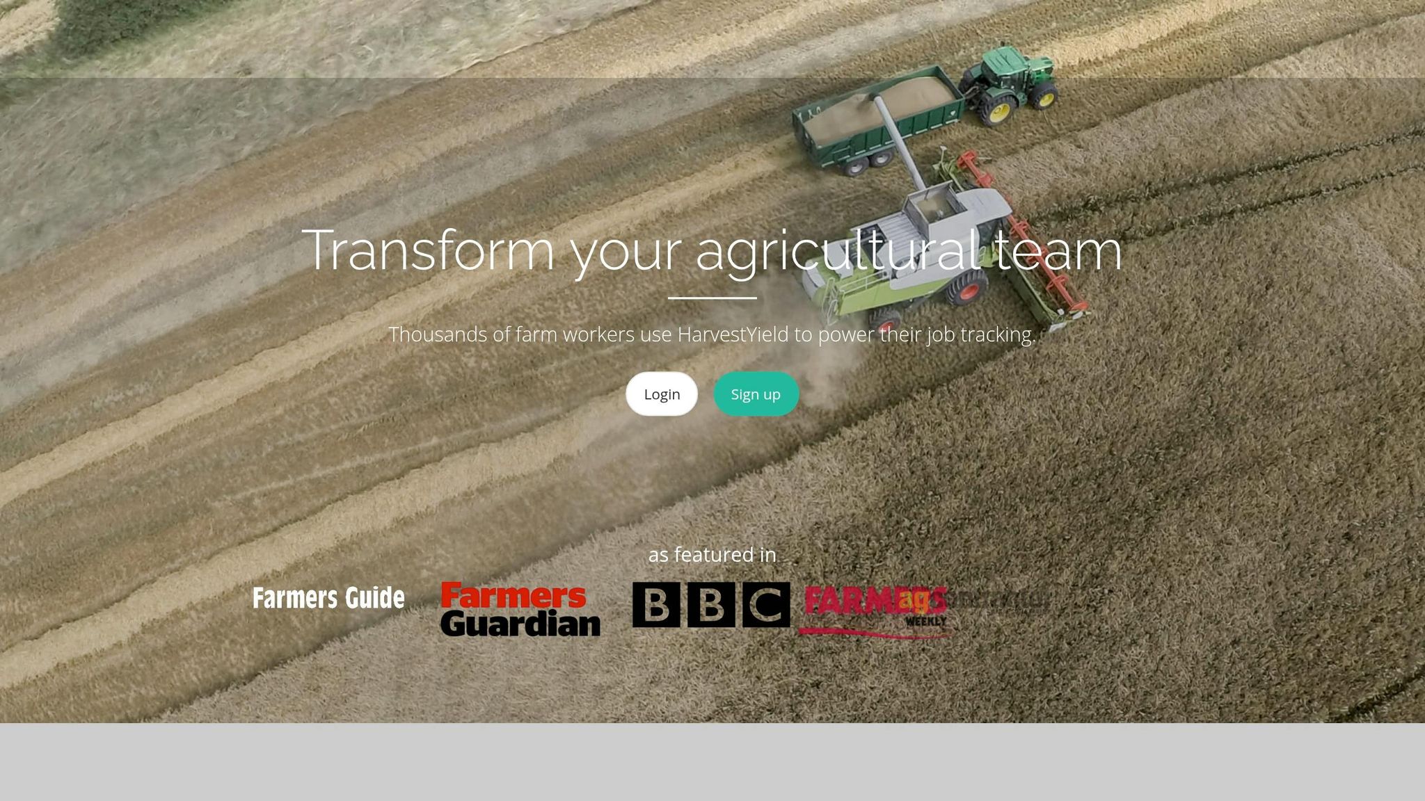
HarvestYield is a digital job management tool designed specifically for agricultural teams, including contractors, farm managers, and small farm owners. It replaces traditional paper job sheets with a streamlined digital system that automatically records GPS data, weather conditions, and machinery details the moment a job begins.
Live GPS Guidance and Logging
Once a job is started, the platform begins tracking equipment details such as path, speed, distance covered, and start/finish times. It also logs current weather conditions alongside the GPS trail. Managers receive location updates every 10 minutes via dropped pins, enhancing safety for workers operating alone in remote areas.
For instance, during January 2020, Houlston Contracting adopted HarvestYield for 12 team members during silage season. The platform proved invaluable for tracking machinery maintenance, such as identifying that a specific diesel filter lasted only 189 hours. It also helped seasonal staff, unfamiliar with the area, navigate directly to fields using stored GPS coordinates.
"Keeping track of hours has always been via paper timesheets submitted weekly... all but two of the regular staff are now recording jobs and inputting worked hours via their smartphone, which is linked straight back to the office." - Steven Houlston, Partner, Houlston Contracting
Offline Capability for Remote Fields
HarvestYield ensures uninterrupted functionality by storing all GPS and job data locally on the device. This data automatically syncs to the cloud as soon as an internet connection becomes available.
Job and Work-Order Tracking
The platform allows managers to schedule tasks and receive push notifications when jobs begin or end. Digital job sheets track essential details like seed rates, fuel consumption, and bales produced. These records can integrate seamlessly with invoicing tools such as QuickBooks, Sage, or Farmplan. For added transparency, a GPS-generated coverage map can be attached to invoices, offering clients clear proof of completed work. This comprehensive system simplifies managing and documenting every field activity.
HarvestYield pricing starts at $49/month for up to 250 active acres, with $149/month covering up to 1,000 acres and $379/month up to 5,000. Every paid tier includes unlimited team members, and annual billing saves about two months. The app has a 3.8/5 rating on the Apple App Store and has been downloaded over 5,000 times on Google Play.
2. OneSoil Scouting
OneSoil Scouting is a field monitoring app that over 140,000 farmers in 180 countries rely on every year. By combining satellite imagery with AI, it helps farmers spot crop stress early - before small issues turn into big problems.
Field Mapping and Boundaries
Setting up fields is quick and easy. OneSoil’s AI can automatically detect field boundaries using satellite imagery, so there’s no need to draw them manually. If you already have boundary files in formats like KML, KMZ, GeoJSON, or ZIP shapefiles, you can upload those directly. For farms with irregular layouts, you also have the option to draw boundaries by hand or choose from a database of predefined ones. These flexible tools make managing fields much simpler.
Live GPS Guidance and Logging
Instead of just tracking equipment paths, OneSoil takes you straight to the areas that need attention. Using GPS and NDVI biomass maps, the app guides you to stress zones in your fields. Once on-site, you can log observations, tag issues, and attach geotagged photos, creating detailed, location-specific records. Its "AI Agronomist" feature prioritizes fields based on urgency, so you focus on what matters most instead of walking endless acres. Plus, the app works seamlessly offline, ensuring you can scout without interruptions.
Offline Capability for Remote Fields
Even if you’re in an area with poor cell service, OneSoil keeps you covered. You can still create georeferenced notes, attach photos, and mark problem areas while offline. Once you’re back online, the app syncs everything automatically. Just activate offline mode before heading into remote areas.
Job and Work-Order Tracking
OneSoil’s Field Diary helps you stay on top of task management. It logs activities like spraying, fertilizing, and seeding, while Task Maps assist in planning upcoming fieldwork. Managers, agronomists, and operators can update and view field notes in real time, ensuring everyone stays on the same page. For more advanced tasks - like creating variable-rate application (VRA) maps or analyzing long-term productivity trends - the web-based OneSoil Pro provides additional tools.
The app’s core features, including field mapping, basic weather updates, and scouting notes, are free. A subscription unlocks extras like season-long satellite history, hyperlocal precipitation forecasts updated every four hours, and field boundary downloads. With a 4.6/5 rating from about 12,000 reviews on Google Play, it’s clear that many users find value in the app, though some mention it can slow down during busy times like spraying season.
"OneSoil productivity zones correlate with our harvest data accurately. The app helped us in better and more precise fertilizer distribution for higher yields!" - Jonas Horsch, KORA PS k.s. and Agrospol Blsany
3. Tractor GPS – Field Guidance
Tractor GPS – Field Guidance is a handy Android app designed for precise field activity tracking. Its simple interface and ability to work offline make it a reliable choice for farmers. By using your device's built-in GPS, it offers accurate and affordable navigation for various field tasks.
Field Mapping and Boundaries
The app ensures straight, parallel passes across your field by displaying visual guidance lines on the screen. This helps eliminate overlaps or missed spots during activities like spraying, planting, fertilizing, or harvesting. You can also set up equipment presets, such as working width and offset, to tailor the guidance to your specific needs. This level of accuracy lays the groundwork for real-time task tracking during fieldwork.
Live GPS Guidance and Logging
With real-time A/B line guidance and a live coverage map, you can monitor your progress as you work. The app logs important details for every session, including the area covered, distance traveled, time spent, and any notes you add. This makes it easier to keep track of your activities and plan more efficiently.
Offline Capability for Remote Fields
Since the app relies on your device's GPS, it works seamlessly without an internet connection. This is especially useful for fields in remote areas where cell service might be spotty. You can still follow guidance lines and track your coverage without interruptions.
4. Precision Tracking Farm Management App
The Precision Tracking Farm Management App, part of the FieldBee platform, combines accurate GPS guidance, real-time tracking, and detailed task logs into one streamlined tool. This makes it a go-to choice for farmers who need advanced mapping and tracking features.
Field Mapping and Boundaries
With this app, you can create digital field maps by either drawing boundaries manually or importing existing ones. It includes an in-app GPS field area measurement tool to calculate the total size of fields, blocks, or paddocks. You can measure perimeters using live GPS tracking or by selecting points manually, which generates a satellite-based layout.
Live GPS Guidance and Logging
FieldBee takes mapping to the next level with its high-precision GPS navigation. It supports various field patterns, multiple U-turn types, and works with both manual guidance and autosteer systems. The app tracks real-time coverage and logs every task - from planting to harvesting - so you always have a clear record of your progress.
Offline Capability for Remote Fields
While offline functionality is somewhat limited, you can preload maps before heading into areas without cell service. These cached maps allow basic offline use, with full offline support expected in the future.
Transform Your Agricultural Team
Streamline job management, field mapping, and machine tracking with HarvestYield. Simplify your operations and eliminate paper job sheets.
Continue5. Farm Equipment GPS Tracking App
Field equipment GPS apps like Field Navigator and AgriBus-NAVI provide operators with real-time navigation and tracking, offering accurate guidance without the need for expensive hardware.
Field Mapping and Boundaries
These apps let you map field boundaries by either driving around the perimeter or placing pins on satellite images. The result? A digital field database that remains consistent year after year. Once obstacles like rocks, irrigation heads, or power lines are identified and logged, they’re visible to all operators, ensuring a shared, up-to-date record. You can also export field data in formats like KML, KMZ, or Shapefile, making it easy to integrate with other farm management tools.
With this digital database in place, operators can rely on precise navigation for various tasks, streamlining operations and improving efficiency.
Live GPS Guidance and Logging
These apps guide equipment along AB straight lines, AB curves, and headland patterns, ensuring evenly spaced rows and reducing overlaps. This level of precision helps cut down on wasted inputs like seeds or chemicals.
"Straight and evenly spaced work makes it possible to skip one line of work." - AgriBus
Smartphone GPS provides accuracy within about 6.5 feet (2 meters). However, pairing your device with an external Bluetooth receiver can improve accuracy to 0.2–0.3 meters, while RTK systems push it even further to 0.02–0.03 meters. This level of precision is especially critical for tasks like row-crop seeding and spraying. With over 1 million downloads and a 4.6/5 rating on Google Play, Field Navigator has proven its reliability.
Offline Capability for Remote Fields
For areas with limited connectivity, both apps offer offline functionality. The key is to preload your maps before heading out of signal range. Once the maps are cached, the apps continue to provide guidance and log data seamlessly. When you’re back online, everything syncs to the cloud, ensuring no data is lost during your operation.
6. General Farm Management App With GPS Activity Logging
General farm management apps take GPS tracking to the next level by combining it with tools for job planning, team coordination, and field documentation. These apps streamline multiple aspects of farm operations into a single platform, making them a practical choice for modern farmers.
Field Mapping and Boundaries
These apps allow users to map field boundaries using GPS tracking, whether by walking, driving, or drawing directly on satellite imagery. For example, fieldmargin has earned a 4.2/5 rating on the App Store from 100 reviews. Users appreciate how easy it is to audit field history and tag issues with photos, simplifying field management.
Offline Capability for Remote Fields
Both fieldmargin and Farmable include offline functionality, which is a game-changer for remote areas with limited connectivity. You can map fields and log activities locally, and the data syncs automatically once you're back online. This ensures that no information is lost, even in areas with poor cell service.
Job and Work-Order Tracking
These apps go beyond mapping by integrating job and work-order management. Tasks like spraying, fertilizing, and harvesting are linked to GPS data, with notes and photos attached to specific locations. For instance, Farmable has been downloaded over 100,000 times and offers a free basic version for up to five spray records. For unlimited task management, users can upgrade to Farmable Pro. Meanwhile, fieldmargin enhances team coordination by displaying live crew locations on an interactive map, helping managers spot delays or gaps in coverage in real time. Pricing for fieldmargin starts at $13.49 per month (or $134.99 annually) for the Essentials plan, with the Pro plan available at $60.99 per month.
"It has hugely minimized time spent collecting and sorting job sheets and allows for a much more accurate and hassle-free way to collect this data." - James Enderby, Contractor
7. Specialized GPS Scouting and Task Logging App
Specialized scouting and task logging apps are designed to streamline field operations by focusing on precise record-keeping and offline syncing. These tools help ensure compliance and efficiency, even in challenging conditions.
Apps like FarmQA cater to agronomy and scouting needs, boasting a solid 4.7/5 rating from 25 users on the App Store. Meanwhile, FarmENGAGE focuses on task assignment and crew coordination, with a 3.3/5 rating from 189 reviews on Google Play.
Field Mapping and Boundaries
These apps make it easy to define and manage field boundaries. You can outline field perimeters by walking or driving the edges, or use drawing tools on satellite imagery to set boundaries. Once marked, the app calculates the total acreage automatically. Additionally, you can highlight obstacles like rocks or irrigation lines within the field to protect equipment. Digital maps sync across your team, ensuring everyone works with the same boundary data, reducing mistakes like applying treatments to the wrong field.
Offline Capability for Remote Fields
A standout feature of these apps is their offline functionality, which keeps data secure even in areas without cellular coverage. For example, FarmQA stores scouting notes, photos, and GPS data locally, syncing everything once you're back online. If your app uses satellite imagery, make sure to pre-load maps before heading out to ensure you have access to necessary visuals in remote areas.
Job and Work-Order Tracking
These tools also excel at managing tasks. Managers can schedule activities like scouting, soil sampling, or spraying, and track their completion with GPS-verified timestamps - perfect for compliance audits. For larger operations with multiple plots, everything is organized in one dashboard, making it easy to scale from small farms to larger enterprises. This specialized approach ensures consistency and reliability across all field tracking activities.
App Comparison Table
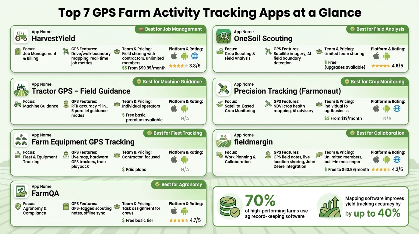
Top 7 GPS Apps for Farm Activity Tracking: Side-by-Side Comparison
Here’s a side-by-side look at the apps:
| App | Primary Focus | GPS Capabilities | Team Features | Pricing | Platform |
|---|---|---|---|---|---|
| HarvestYield | Job management & billing | Drive/walk boundary mapping; real-time job metrics | Field sharing with contractors; unlimited members | Mid-range (paid tiers) | iOS, Android, Web |
| OneSoil Scouting | Crop scouting & field analysis | Satellite imagery; field boundary detection | Limited team sharing | Free | iOS, Android |
| Tractor GPS – Field Guidance | Machine guidance | RTK accuracy to ±1 in.; 5 parallel guidance modes; area/distance tracking | Designed for individual operators | Free basic; premium available | iOS, Android |
| Precision Tracking (Farmonaut) | Satellite-based crop monitoring | NDVI crop health mapping; AI advisory | Scales from individual to agribusiness | From $19/month | iOS, Android, Web |
| Farm Equipment GPS Tracking (FarmBackup) | Fleet & equipment tracking | Live map; hardware GPS trackers; track playback | Contractor-focused; proof-of-work docs | Paid | iOS, Android |
| General Farm Management (fieldmargin) | Work planning & collaboration | GPS field notes; live location sharing; John Deere integration | Unlimited team members; built-in messenger | Free to $60.99/month | iOS, Android, Web |
| Specialized Scouting & Task Logging (FarmQA) | Agronomy & compliance | GPS-tagged scouting notes; offline sync | Task assignment for crews | Free basic tier | iOS, Android |
This table highlights how each app brings something different to the table, catering to specific farming needs. If you’re looking for real-time team collaboration, HarvestYield and fieldmargin deliver strong options. For equipment-focused tasks, Tractor GPS – Field Guidance and Farm Equipment GPS Tracking are excellent choices. Meanwhile, Farmonaut stands out with its satellite-based insights. For those on a budget, OneSoil Scouting and FarmQA offer free tiers with useful features. Lastly, HarvestYield provides scalable tools for growing teams that need advanced job management.
Conclusion
The app reviews above showcase a variety of tools designed to support different farm operations. Since no single app works for every situation, it's crucial to pick the one that aligns with your specific needs.
Farms often have unique priorities - whether it's navigating fields, managing teams, tracking equipment, or monitoring costs. For those managing complex operations, HarvestYield stands out with features like job scheduling, machine cost tracking, GPS data logging, and easy sharing of field records with clients. Its Business plan, priced at $379/month for up to 5,000 active acres, provides room for growing operations - and every paid tier includes unlimited team members. Plus, its offline functionality and automated job logging tackle common challenges faced in daily fieldwork.
Here's something to consider: over 70% of high-performing farms rely on agriculture record-keeping software to make informed decisions. On top of that, mapping software can boost yield tracking accuracy by up to 40% compared to manual methods.
Focus on solving your biggest operational challenge - whether it’s field navigation, team coordination, or cost management - to streamline your farm’s activities. Take advantage of free trials or basic plans to find the app that works best for your operation before committing to a subscription.
FAQs
How accurate is phone GPS for field guidance?
Standard smartphone GPS is a reliable tool for navigation, boundary mapping, and tracking in the field, offering accuracy levels typically between 1 to 3 meters. While it doesn't quite match the precision of RTK hardware, this accuracy is sufficient for tasks like identifying field locations or recording work activities. Tools like HarvestYield take it a step further by boosting accuracy to 95%-98%. They achieve this by integrating GPS data with equipment width, simplifying operations and cutting down the need for paper-based records.
What should I download before going offline?
Before heading into regions with limited internet access, make sure to download NAIP imagery and NRCS soil data specific to your area. These will serve as essential base layers for your maps. Also, confirm that your app offers offline capabilities. This feature will let you store data directly on your device, enabling you to record GPS tracks, document field observations, and handle job details without a connection. When you're back online, the platform will automatically sync everything to the cloud, ensuring your data stays up-to-date.
Do I need RTK or an external GPS receiver?
For most farmers and contractors, the GPS in your smartphone is usually good enough for tasks like mapping, scouting, and logging jobs - and it doesn’t come with any extra costs.
However, if your work demands centimeter-level accuracy - think controlled-traffic farming or mapping drainage systems - you’ll likely need RTK equipment. For simpler tasks, such as basic boundary mapping or guidance, sub-meter GPS receivers or the GPS built into your machinery often do the trick.