Field Mapping Tools for Better Farm Project Reporting
Field mapping tools are transforming how farms manage project reporting by replacing outdated paper-based methods with precise, GPS-enabled digital solutions. These tools provide accurate field boundaries, reduce admin time by up to 75%, and minimize data loss risks tied to manual records. Key features include GPS-verified acreage measurements, real-time job tracking, and seamless data export for compliance. Whether you're managing thousands of acres or a small farm, these tools simplify operations, improve accuracy, and save time.
Top Tools to Consider:
- HarvestYield: Combines GPS mapping, weather data, and job tracking with invoicing features. Free up to 50 acres, with paid plans from $49/month.
- ArcGIS Pro: Advanced GIS platform for detailed spatial analysis; ideal for large, complex setups.
- QGIS: Free, open-source GIS software with customizable plugins for farm data.
- Google Earth: Basic visualization tool for field layouts; free but lacks advanced features.
- Fieldmargin: Integrates mapping with crop planning and team management.
- Agrian: Links GPS data with compliance records and crop input history.
Quick Comparison:
| Tool | Key Features | Best For | Cost |
|---|---|---|---|
| HarvestYield | GPS mapping, weather data, invoicing | Contractors, multi-user teams | Free–$379/month (by acreage) |
| ArcGIS Pro | Advanced spatial analysis | Complex land management | High licensing cost |
| QGIS | Free GIS with plugins | Budget-conscious users | Free |
| Google Earth | Basic field visualization | Quick reference needs | Free |
| Fieldmargin | Mapping + crop planning | Tracking margins and inputs | Free + paid plans |
| Agrian | GPS + compliance tracking | Regulatory-focused operations | Varies |
Choose a tool based on your farm's size, reporting needs, and budget. For contractors or multi-client operations, HarvestYield offers a strong mix of mapping and reporting features.
Key Benefits of Field Mapping for Farm Reporting
Getting Field Boundaries and Acreage Right
Relying on memory or outdated records to estimate field sizes often leads to errors in farm reporting. These inaccuracies can disrupt billing, planning, and compliance. Digital mapping tools solve this issue by using GPS data to calculate boundaries with up to 98% accuracy. For example, on a 500-acre farm, a 10% error could misreport 50 acres, throwing off supply orders, billing, and other critical decisions.
In addition to precise boundary calculations, these tools simplify the recording of operational details, making farm management smoother and more reliable.
Better Job Records with GPS and Weather Data
Mapping tools automatically record essential job details like start and finish times, distance covered, average speed, and location. Take Houlston Contracting, a North Yorkshire-based firm, as an example. They use HarvestYield to manage their silage operations with up to 12 self-employed staff. Operators log bale numbers and wrap rolls directly into the app, while GPS data flags wet patches in fields to warn future operators. This level of detail is especially useful when providing field navigation for new staff. Steven Houlston, the co-owner, shared:
"The app made it easy to see when the last filter change was. On one machine, a set of filters had only done 189 hours."
Even in areas with poor cell coverage, these apps maintain reliable GPS records, syncing to the cloud once a connection is available. This streamlined data capture also speeds up report generation, saving valuable time.
Moving Field Data into Reports Without the Hassle
Manual, paper-based reporting often delays report readiness by 8–14 days due to transcription and sorting. Digital tools eliminate this bottleneck, enabling real-time or same-day reporting. They also cut administrative work from 4–5 hours per week to just 45 minutes. Contractor James Enderby highlighted this benefit:
"It has significantly reduced the time spent on collecting and sorting job sheets and allows for a much more accurate and hassle-free way to collect this data."
With these tools, farm project reports become faster to produce and free from common errors, offering a more efficient way to manage operations.
Transform Your Agricultural Team
Streamline job management, field mapping, and machine tracking with HarvestYield. Simplify your operations and eliminate paper job sheets.
ContinueTools and Tips for Creating Maps of Farm Fields
What to Look for in a Field Mapping Tool
Field mapping tools come in all shapes and sizes, but not all are built with agriculture in mind. For farm reporting, the right tool needs to combine accurate mapping capabilities with smooth data integration. Picking the right features can make all the difference between simplifying your reporting or adding unnecessary headaches.
Field Boundary Drawing and Acreage Calculation
At its core, a field mapping tool should let you draw precise field boundaries and calculate acreage accurately. How you capture these boundaries is a key factor. For most fields, driving the perimeter achieves 95–98% accuracy. However, for smaller or irregularly shaped fields, walking the boundary is often a better choice for greater precision, though it takes more time. Avoid relying on quick pin-drop methods - they’re not reliable enough for billing or meeting compliance standards.
The accuracy of GPS hardware also plays a major role. Here’s a breakdown:
- Smartphones: 10–16 feet precision
- Sub-meter receivers: 1–3 feet precision
- RTK GPS systems: 0.4–1.2 inches precision
For permanent boundaries and precision farming, RTK GPS is the gold standard. Accurate boundary mapping also pairs seamlessly with GPS tagging for tracking field activities.
GPS Data Capture and Location-Tagged Records
A good mapping tool doesn’t just map fields - it tags every activity with precise GPS data. This context turns raw data into actionable insights for better decision-making.
"Using GPS trackers, I can ensure that everything is registered automatically, regardless of who is driving. We can now see whether leased fields pay off in terms of the use of machines." - Heine Kjeldgaard, Arable and Pig Farmer
With automatic location tagging, you eliminate guesswork and reduce disputes about what work was done and where. It also simplifies reporting, making it easier to track operations over time.
For GPS data capture to be truly effective, the tool should allow for easy exporting and work seamlessly across multiple devices.
Exportable Data and Multi-Device Support
Avoid tools that lock your data into a closed system. Choose a mapping tool that lets you export data in formats you can actually use - whether for invoicing, compliance reporting, or sharing insights with an agronomist. Being able to transform field data into reports, spreadsheets, or client records is a must for efficient farm management.
Multi-device functionality is just as important. Field operators need tools that work reliably on smartphones or tablets, even in areas with poor cellular coverage. Meanwhile, office staff should have easy access to the same data from a desktop. A tool that syncs automatically when a connection is available ensures everyone stays aligned without the hassle of manual updates.
Top Field Mapping Tools for Farm Reporting
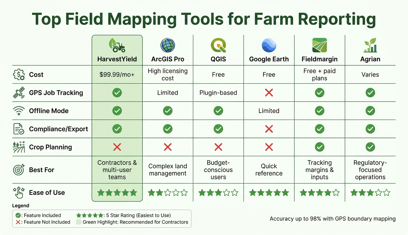
Top Field Mapping Tools for Farm Reporting: Side-by-Side Comparison
When it comes to farm project reporting, having the right tools can make all the difference. From specialized agricultural platforms to advanced GIS solutions, these tools cater to a variety of needs - whether you're looking for simplicity or advanced analytics. The goal? Better data accuracy and smoother reporting processes.
Here’s a closer look at some standout field mapping tools that can elevate your farm reporting game.
HarvestYield
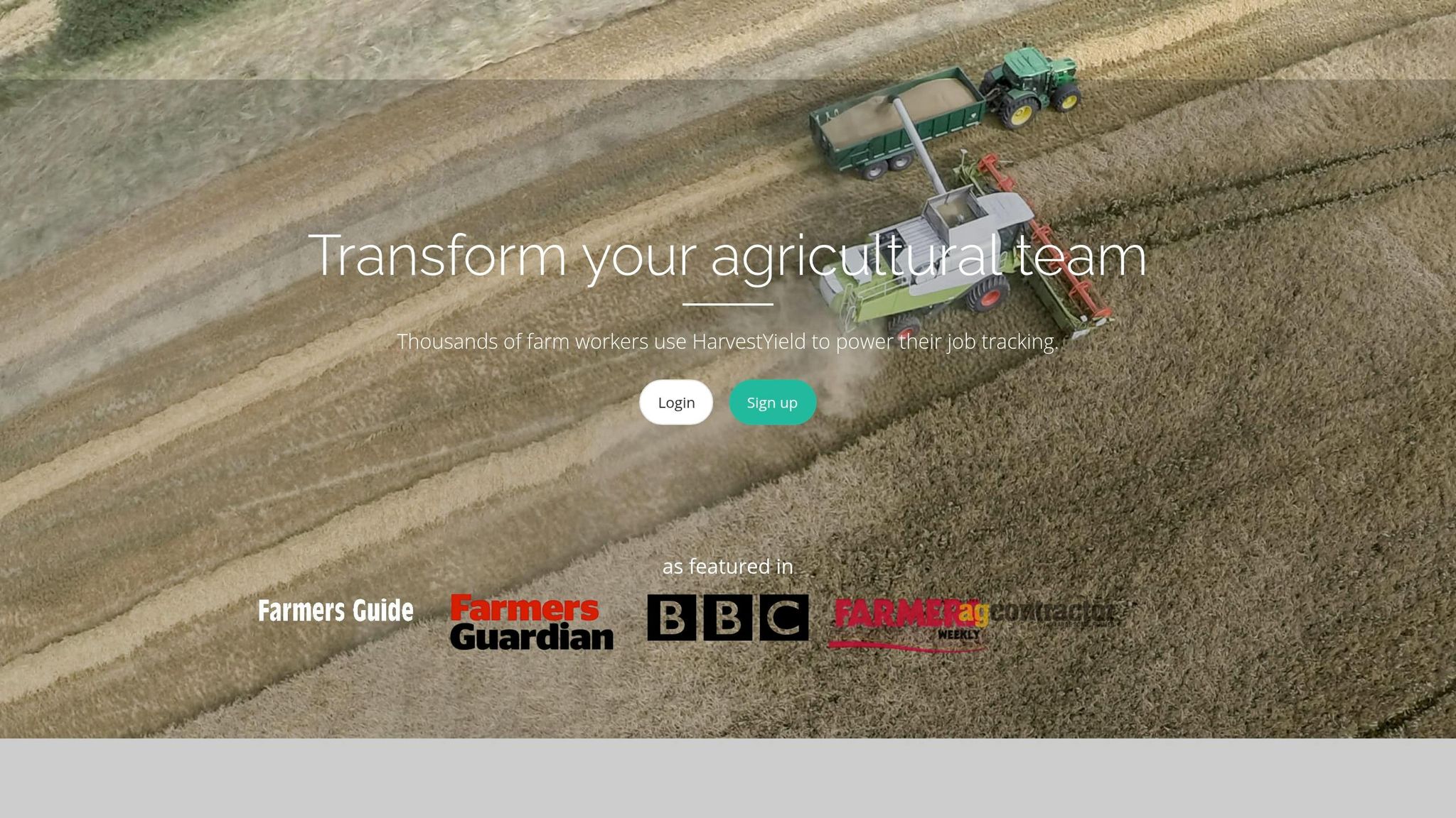
HarvestYield is designed for agricultural professionals like contractors, farm managers, and small farm owners who need more than just basic mapping. This platform combines field mapping with GPS job tracking, automatic weather data integration, and client record management. Every job logged includes location data and real-time weather conditions, making it a comprehensive tool for managing farm operations.
What makes HarvestYield shine is its ability to integrate field data seamlessly with other parts of your workflow. For example, job sheets automatically sync with invoices, machine cost tracking, and client records - eliminating the need for manual data entry. It’s available on iOS, Android, and the web, ensuring access across devices. Pricing starts at $49/month for up to 250 active acres, while larger operations can opt for Pro at $149/month (up to 1,000 acres) or Business at $379/month (up to 5,000 acres), each with unlimited team members.
If advanced spatial analysis is what you need, ArcGIS Pro might be your next stop.
ArcGIS Pro
ArcGIS Pro by Esri is a top-tier GIS platform ideal for users who need advanced spatial analysis and multi-layered map data. It’s particularly useful for farms managing complex land arrangements or dealing with regulatory requirements. The platform allows for detailed field boundary mapping, layered data visualization, and professional reporting outputs.
However, it’s worth noting that ArcGIS Pro requires a higher level of technical expertise and comes with steeper licensing costs. But for those who demand precision and robust analytics, it’s a tool that delivers exceptional results.
For a more budget-friendly option with strong customization capabilities, QGIS is worth considering.
QGIS
QGIS is a free, open-source GIS tool that offers flexibility for creating detailed field maps and managing editable map layers. While it doesn’t come with built-in agriculture-specific features, its extensive plugin library allows users to tailor the software to their farm data needs. This makes it a great choice for farm managers or agronomists who are comfortable working with GIS software and want a cost-effective solution.
If you’re after simplicity and ease of use, Google Earth offers an entry-level option.
Google Earth
Google Earth is a free and familiar tool that’s perfect for basic field visualization and boundary reviews. It allows users to drop pins, draw polygons, and get a bird’s-eye view of their land with minimal effort. While it’s not designed specifically for farm reporting and lacks features like GPS job tracking or exportable data, it’s a handy tool for quick reference or communicating field layouts to clients.
For those looking to combine mapping with crop planning, Fieldmargin offers an integrated approach.
Fieldmargin
Fieldmargin goes beyond mapping by integrating crop planning and task management into its platform. It uses GPS for boundary mapping and team location sharing, while also generating reports on gross margins, nutrient management, and input usage. These features are not only useful for internal tracking but also for meeting compliance requirements.
The app has a 4.0/5 rating on Google Play from 445 reviews (as of May 2026), and it offers a free version alongside Plus and Pro tiers available via in-app purchases.
"Fieldmargin has been instrumental in documenting our regenerative transition. The ability to visualize our farm and track the impact has been invaluable." - Nathan Nelson, Deepdale Farm
For farms needing a tool that ties field mapping directly to compliance records, Agrian offers a specialized solution.
Agrian
Agrian excels at connecting field mapping with crop input history and compliance records, making it a go-to choice for farms requiring detailed operational tracking over multiple seasons. It captures GPS-based field data and links it to application records, which simplifies the preparation of compliance documentation and audit-ready reports.
Field Mapping Tools Side by Side
Let’s take a closer look at how HarvestYield stands out when it comes to farm project reporting and field mapping.
| Tool | Core Mapping Features | Reporting & Export Strengths | GPS & Data Capture | Best Fit |
|---|---|---|---|---|
| HarvestYield | Boundary mapping, entrance pins, color-coded clients | Job history, weather-tagged records, invoicing | GPS job tracking, automatic weather data | Contractors and multi-user teams |
HarvestYield combines essential mapping tools with advanced reporting features, making it a go-to solution for farm operations. It offers GPS-verified boundary mapping and integrates real-time weather data, which simplifies job tracking and enhances reporting accuracy. Additionally, its ability to link field data directly with job scheduling, machine cost tracking, and client records creates an all-in-one workflow for farm management.
One of HarvestYield’s standout features is its export capability. It allows users to generate structured, audit-ready reports in just minutes. This makes it an excellent choice for contractors managing multiple clients or farm teams that require reliable, up-to-date data. By streamlining mapping, GPS data capture, and reporting, HarvestYield provides an efficient and precise tool for farm operations of all sizes.
Choosing the Right Field Mapping Tool for Your Farm
When picking a field mapping tool, it’s all about focusing on the essentials. For starters, make sure the tool works offline. This is crucial for capturing data in remote areas where cell service is spotty. Additionally, look for GIS export formats like .shp and .kml - these are invaluable for sharing data with agronomists, submitting compliance reports, or dealing with government programs.
Another key feature is the ability to link field locations to job details. A map that only shows where work happened, without tying it to job specifics, leaves major gaps in your reporting. When mapping integrates with job data, every recorded detail becomes actionable, helping you make better operational decisions. Here's a quick breakdown of the must-have features and why they matter:
| Feature | Priority Level | Why It Matters |
|---|---|---|
| Offline Mode | Critical | Ensures data capture in areas with no cell service |
| GIS Export (.shp, .kml) | High | Essential for compliance, sharing with professionals, and government reporting |
| Job Integration | High | Links field locations with job details like what was applied and by whom |
| RTK Accuracy | Optional | Useful only for precision tasks like variable-rate seeding |
| Color-Coding | Medium | Makes it easier to manage multiple clients or crop types visually |
By prioritizing these features, you’ll not only improve the reliability of your reports but also cut down on administrative headaches.
For contractors managing multiple clients or large-scale operations, tools like HarvestYield stand out. This platform combines GPS job tracking, weather data, and client records into a single streamlined system, making it easier to generate accurate, audit-ready reports. As Philip Hoff, a farmer from Bowdon, ND, shared:
"If you throw out some ideas at them, they are always willing to listen and execute on those ideas. Best bang for the buck out there." - Philip Hoff, Farmer, Bowdon, ND
FAQs
How do I map a field boundary accurately?
To map a field boundary precisely, use a GPS-enabled device while walking or driving along the perimeter. If driving, maintain a speed of 5–10 mph, stay 5–10 feet inside the boundary, and keep the device close to a window to ensure a strong signal. For smaller fields, walking is a better option for improved accuracy. Another method is dropping GPS pins at key corners or using aerial imagery to outline the field, which can later be fine-tuned through on-the-ground GPS verification.
Will field mapping apps work without cell service?
Smartphones and tablets don’t need cellular service to map boundaries or track movement - they depend on GPS signals instead. Many modern field mapping apps, like HarvestYield, are designed to work entirely offline. These tools let you record GPS tracks, take photos, and save data directly on your device. When you reconnect to a network, the app automatically syncs the stored data, keeping everything updated and secure.
What file types should I export for compliance or agronomists?
To collaborate with agronomists or adhere to compliance standards, it's important to export data in formats that work seamlessly with mapping and analysis tools. Commonly recommended formats include shapefiles, GeoJSON, KML, and ISO-XML.
For professional reporting, PDF files are ideal. They help you document work history, keep accurate records, and present information clearly - whether for client meetings or compliance reviews.