How GPS Field Mapping Improves Contractor Operations
GPS field mapping is transforming contractor operations by replacing manual tools like tape measures and hand-drawn diagrams with precise, satellite-based digital mapping. Here's why it matters:
- Saves Time: Traditional field mapping takes 4–8 hours per field. GPS reduces this to as little as 20 minutes.
- Improves Accuracy: Consumer-grade GPS offers 10–16 feet precision, while advanced RTK systems achieve accuracy within 0.4–1.2 inches.
- Cuts Costs: Contractors save $5–10 per acre by reducing input waste, fuel usage, and rework expenses.
- Boosts Efficiency: Automated processes free up 20–30% more time for billable tasks and simplify administrative work like invoicing and compliance reporting.
- Enhances Coordination: Real-time tracking enables better scheduling and team communication, reducing delays by 35%.
For example, Pacific Ag Solutions improved boundary accuracy to 99.5% and saved $28,000 in fuel within one season using GPS. Tools like HarvestYield streamline this further by integrating mapping, job management, and cost tracking into one system.
Switching to GPS field mapping not only simplifies operations but also drives measurable savings and efficiency gains for contractors.
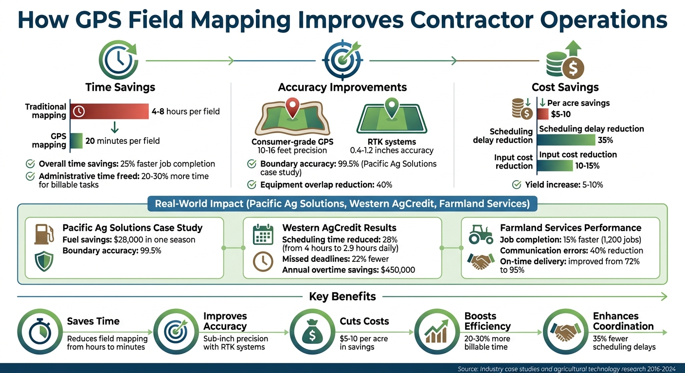
GPS Field Mapping Benefits: Time Savings, Cost Reduction, and Efficiency Gains for Contractors
How GPS Field Mapping Improves Efficiency
Reducing Manual Work and Errors
GPS field mapping takes the guesswork out of measuring field boundaries. Instead of relying on manual tools and tedious measurements, contractors can simply drive along the perimeter while a GPS device records the coordinates. The result? A precise digital map that not only saves time but also provides solid documentation. This kind of clarity can be a lifesaver during billing disputes, as field coverage tracking shows exactly what area was covered. By automating data collection, GPS mapping also ensures that equipment in the field operates more effectively.
Better Equipment Usage
With GPS technology, equipment can follow optimized AB lines - predefined paths that guide machinery across the field. These lines help minimize unnecessary turns and maximize efficiency. Take, for example, a March 2016 case study from Shorter, Alabama. A producer adjusted their AB line orientation from 170° to 80°, which led to a 154% increase in pass length and a 62% reduction in turns for 18-foot equipment. This adjustment cut down on fuel usage and reduced wear and tear on the machinery.
"Guidance technology provides a machine operator the ability to accurately operate a defined field pattern. These systems also improve driving performance by reducing the number of skips and overlaps as well as limiting crop damage during field operation." - Aurelie Poncet et al., Food, Agricultural and Biological Engineering, Ohio State University
Automated steering systems are another game-changer. They reduce operator fatigue, ensuring consistent accuracy even during long workdays. For contractors juggling multiple crews, this level of precision translates to more reliable job timelines and lower maintenance costs.
Saving Time with Automated Processes
GPS systems don't just streamline fieldwork - they also simplify administrative tasks. These systems automatically log start and finish times, GPS locations, and coverage paths, giving managers real-time updates on job progress. This eliminates the need for constant check-ins with operators. Plus, the data flows directly into office systems, speeding up invoicing, payroll, and compliance reporting. Considering that administrative tasks can eat up 20–30% of billable hours, this automation allows contractors to handle more work without adding staff. Tools like HarvestYield take it a step further, letting operators attach photos and notes to specific GPS-mapped locations. This creates a complete digital record for every job, making documentation easier and more reliable.
Transform Your Agricultural Team
Streamline job management, field mapping, and machine tracking with HarvestYield. Simplify your operations and eliminate paper job sheets.
ContinueBetter Job Scheduling and Team Coordination
Real-Time Field Visibility
Efficient scheduling and coordination are just as critical as improving field operations. GPS field mapping offers managers a live, up-to-the-minute snapshot of all job sites without the need for constant phone calls. Instead of relying on end-of-day updates, you can instantly see which fields are finished, which crews are currently working, and where equipment is located. This real-time insight is especially useful when juggling multiple projects - if one crew wraps up early, you can quickly reassign them to another job rather than letting time and resources go to waste.
A 2024 Farmers Edge study of over 500 farms in North America revealed that real-time GPS tracking reduced scheduling delays by 35% and significantly improved coordination. When unexpected problems arise, like equipment malfunctions or weather-related challenges, managers can reallocate resources in minutes rather than hours. Studies on agricultural technology adoption show this responsiveness can cut downtime by 15-20%, as decisions are based on current conditions instead of outdated reports. This kind of visibility ensures that job assignments are made efficiently and in real time.
Simplified Job Assignments
GPS technology has completely changed how contractors assign tasks to their teams. Instead of manually figuring out which crew should handle a specific job, tools like HarvestYield use GPS data to match workers with nearby fields, cutting down on both travel time and fuel costs by using precise field navigation. These platforms consolidate crew locations, equipment status, and field details into a single view, making it easier to assign tasks quickly and accurately.
For example, in 2023, Western AgCredit, a California contractor group, adopted John Deere's GPS Operations Center and saw a 28% drop in the time spent on job scheduling. What used to take 4 hours daily was reduced to just 2.9 hours across 15,000 acres. Operations Manager Tom Reilly highlighted how real-time visibility allowed them to reassign crews dynamically, resulting in 22% fewer missed deadlines and saving $450,000 annually in overtime costs. By automatically matching the right equipment to each field’s size and terrain, they eliminated much of the guesswork that previously slowed them down.
Better Team Communication
Streamlined assignments are only part of the equation - clear communication is equally important for making timely adjustments. Shared GPS data ensures that everyone, from field teams to office staff, operates with the same information. Instead of vague directions like "the north field by the big tree", teams share precise GPS coordinates and digital maps that everyone can access in real time.
During the 2022 harvest season, Midwest contractor Farmland Services used Trimble's Farmer Core platform with GPS mapping to complete 1,200 jobs 15% faster. Project coordinator Lisa Grant noted that integrating GPS data into their workflow reduced communication errors by 40% and improved on-time delivery rates from 72% to 95%. When issues arose, crews marked exact GPS locations with notes and photos, which office staff could view instantly. This eliminated the need for multiple phone calls, allowing schedules to be adjusted or clients to be notified immediately. Shared access to this data typically reduces communication-related delays by 30-40% and improves first-contact problem resolution rates from 45% to 75%.
GPS Boundary Mapping
For more visual guides, explore our collection of agricultural videos.
Reducing Costs Through Accurate Field Mapping
Using accurate GPS field mapping can help cut costs significantly by eliminating unnecessary surveys, lowering fuel consumption, and making the most of available resources.
Lower Surveying and Rework Costs
GPS field mapping reduces the need for expensive third-party surveyors. Instead of spending hundreds or even thousands of dollars on professional land surveys, contractors can handle mapping themselves with GPS technology. By using implement-width AB lines, digital mapping ensures precise, gap-free passes, which helps avoid costly rework and saves on fuel. Overlapping or skipping passes not only wastes time and fuel but also increases wear on equipment, often leading to additional expenses for rework.
The initial setup cost for GPS mapping depends on the level of precision you need. Entry-level options, like phone-based GPS guidance apps, cost about $30 per year. SBAS/WAAS GPS hardware ranges from $2,000 to $5,000, while RTK GPS systems, which offer higher accuracy, cost between $5,000 and $15,000 or more. Fully integrated RTK systems with auto-steer capabilities can range from $10,000 to $25,000+. These upfront costs are offset by savings in surveying, fuel, and maintenance over time.
Fuel and Maintenance Savings
GPS mapping helps you plan efficient driving patterns - whether straight lines, curves, or headland turns - to minimize travel distance and time. By following optimized routes, you can reduce fuel consumption and avoid overlapping tasks like double-spraying or double-sowing. Real-time visibility ensures that machinery doesn’t cover the same ground twice, further lowering fuel use.
Accuracy plays a significant role here. Manual steering provides about 30–50 cm accuracy, while RTK GPS systems can achieve precision within 2–4 cm. This level of accuracy not only saves fuel but also reduces ground compaction, which can affect soil health. Fewer redundant passes mean fewer operating hours, less wear and tear on equipment, and lower maintenance costs.
Better Resource Allocation
Accurate field mapping goes beyond immediate cost savings by enabling smarter resource allocation. Detailed field data helps match tasks with the right machinery and labor, reducing idle time and preventing overuse of expensive equipment. GPS mapping also identifies usage trends across jobs, such as fields that consistently take longer or equipment combinations that perform better.
With this data, you can fine-tune crew sizes, equipment assignments, and time estimates based on actual performance rather than assumptions. This leads to fewer idle machines, better-utilized labor, and more accurate job quotes - helping to protect your profit margins while improving overall efficiency.
Using GPS Field Mapping with HarvestYield
HarvestYield takes the precision of GPS mapping and pairs it with a robust job management system, making contractor operations smoother and more efficient.
Integrated GPS and Job Management
HarvestYield combines mapping, scheduling, and record-keeping into one platform. You can easily create field boundaries by either driving the perimeter using the mobile app or dropping pins on aerial imagery. The system then calculates the acreage automatically, ensuring accurate inputs and billing.
Once fields are mapped, you can assign jobs with digital job sheets that include turn-by-turn directions for operators. The system tracks GPS coverage, timestamps, and even local weather conditions automatically, giving you a detailed record of each task.
Easy Data Sharing and Documentation
HarvestYield simplifies data collection and sharing. Operators can log material quantities, upload photos, and add field-specific notes. All this information feeds directly into invoices and compliance reports. You can also track machine costs - such as repairs, servicing, and fuel - linking them to specific jobs or fields to calculate the exact operating cost per acre.
The platform works seamlessly across iOS, Android, and web browsers with cloud syncing, ensuring office staff and field operators are always on the same page. Even in areas with poor connectivity, HarvestYield allows offline access to maps and GPS tracking. Data automatically syncs once the device reconnects to the internet.
Improving Team Productivity with HarvestYield
To keep operations running smoothly, standardize workflows and use consistent field naming conventions (e.g., "Client Name - Field 3A") to minimize confusion. Update field maps annually to reflect any changes and maintain an audit trail by documenting mapping dates, GPS accuracy, and user details. These practices help crews work more efficiently, cutting downtime and increasing profitability.
For tasks requiring high precision, such as variable-rate applications, you can connect external sub-meter or RTK GPS receivers to mobile devices via Bluetooth. This boosts accuracy from around 15 feet to as precise as 1–2 inches. Additionally, role-based access settings allow managers full control while giving operators view-only access, safeguarding sensitive data while keeping everyone informed.
Conclusion
GPS field mapping has reshaped how operations are managed by automating measurements, reducing mistakes, and lowering costs. Contractors using GPS technology report completing jobs 25% faster and reducing equipment overlaps by 40%, which translates to savings of $5–10 per acre. This combination of efficiency and accuracy not only boosts productivity but also strengthens client relationships by ensuring precise and reliable documentation.
Switching from paper-based workflows to digital GPS mapping gives you better control over operations and helps drive growth. In precision agriculture, GPS mapping typically reduces input costs by 10–15% while increasing yields by 5–10%. With every field boundary, job timestamp, and equipment pass tracked automatically, you eliminate the guesswork that often leads to costly errors or disputes. This streamlined approach sets the stage for smoother management across all aspects of your work.
HarvestYield brings field mapping, scheduling, and cost tracking into one unified system tailored for agricultural contractors. It provides real-time updates on field progress, automated documentation synced across your team, and actionable data for better resource management and pricing decisions. These tools make it easier to start improving operations right away.
If you're unsure about diving in, start small. Test the benefits with a pilot project - map a few fields, track equipment usage on select jobs, and see the time savings for yourself. Contractors often report 15–20% time savings immediately, with most achieving a return on investment within the first year. As the demand for digital documentation and transparency grows, staying competitive means embracing GPS technology.
Schedule a demo with HarvestYield today to move away from manual processes and adopt automated, real-time mapping that saves money and gives you a leading edge in modern agriculture.
FAQs
Do I need RTK accuracy, or is standard GPS enough?
Standard GPS is usually sufficient for most field mapping and contractor tasks. However, when centimeter-level precision is required - like in detailed surveying - RTK accuracy (ranging from 0.4 to 1.2 inches) becomes essential. Assess the specific demands of your project to decide which level of accuracy is right for you.
How fast does GPS field mapping pay for itself?
GPS field mapping can quickly prove its value by reducing mistakes, streamlining operations, and making better use of resources. Over just a few growing seasons, these advantages translate into noticeable cost savings and greater productivity for both contractors and agricultural teams.
What should we do when there’s no cell service in the field?
When you're working in areas without cell service, rely on GPS devices designed for offline use. Many handheld GPS units and tools like HarvestYield let you collect data offline, making it possible to keep up with mapping and tracking tasks even in remote locations.
Before you head out, double-check that your device has enough battery life and storage space. Once you're back in a spot with internet access, you can upload the collected data to your management platform for analysis and safe recordkeeping.