RTK GPS: Precision in Field Boundary Mapping
RTK GPS (Real-Time Kinematic GPS) delivers centimeter-level accuracy, making it an ideal tool for precision agriculture. Unlike standard GPS systems with errors of 10–16 feet, RTK GPS reduces this margin to just 2–3 cm. This accuracy is critical for mapping field boundaries, ensuring efficient planting, spraying, and fertilizing while minimizing waste and costs.
Key Takeaways:
- RTK GPS achieves ±1 inch repeatability, essential for consistent field boundary mapping.
- It uses a base station and rover system to correct GPS errors in real-time.
- Farmers can save up to 10% on inputs by reducing overlaps in field operations.
- RTK data integrates seamlessly with farm management software for accurate job tracking.
RTK GPS is transforming how farmers manage their fields, offering precision that supports better resource allocation, compliance, and long-term operational efficiency.
Key Components of RTK GPS for Field Mapping
RTK System Components
An RTK system relies on three main parts: a base station, a rover receiver, and a communication link.
The base station is a stationary GNSS receiver set up at a spot with known coordinates. It monitors satellites and calculates corrections for atmospheric delays and clock errors. Meanwhile, the rover - a mobile unit attached to equipment like a tractor, ATV, drone, or even a handheld device - receives the same satellite signals and applies those corrections to achieve centimeter-level accuracy.
The communication link bridges the base and rover. Two popular options are:
- UHF/VHF radio: Operates within a range of 5–10 miles.
- Cellular modems using NTRIP (Network Transport of RTCM via Internet Protocol): Streams correction data over the internet from a network of permanent base stations.
For many farmers, NTRIP subscriptions - starting at about $40 per month - are a more economical alternative to owning a local base station, which can cost anywhere from $5,000 to $15,000 upfront.
RTK receivers also track multiple satellite constellations, such as GPS, GLONASS, Galileo, and BeiDou. This multi-constellation capability ensures a reliable "Fixed" signal, even in areas with obstacles like trees or uneven terrain.
Together, these components deliver the accuracy required for precise field mapping.
Accuracy and Performance Metrics
The combination of these elements allows RTK systems to achieve precision that's essential for tasks like legal boundary mapping and controlled-traffic farming.
RTK accuracy is measured in two ways:
- Pass-to-pass accuracy: Consistency within a single session.
- Absolute accuracy: The system's ability to maintain true Earth coordinates over time, which is especially critical for legal records and repeatable guidance.
Here’s how different correction levels compare:
| Correction Tier | Pass-to-Pass Accuracy | Typical Use Case |
|---|---|---|
| Standard GPS | 10–16 feet (3–5 m) | General navigation, rough scouting |
| SBAS (WAAS) | 6 inches–2 feet (15–60 cm) | Broad-acre spraying, spreading |
| RTK (Fixed) | 0.4–0.8 inches (1–2 cm) | Precision planting, strip-till, legal boundaries |
It’s important to wait for an "RTK Fix" to ensure maximum accuracy. Operating in Float mode can lead to positional uncertainty, with errors ranging from 8 to 20 inches (20–50 cm).
Reference Systems in U.S. Agriculture
A consistent coordinate system is crucial for RTK’s accuracy to translate into dependable field boundary records. In the U.S., the standard is NAD83 (North American Datum of 1983), which serves as the legal reference for RTK corrections and permanent records. While raw satellite data is often provided in the global WGS84 frame, converting it to NAD83 locally avoids errors. If the two systems are mixed without proper transformation, offsets of over 3 feet can occur, potentially misplacing field boundaries.
The National Geodetic Survey (NGS) is transitioning to a new system called NATRF2022, designed to align U.S. coordinates more closely with global satellite constellations. This update could shift existing GPS coordinates by 1–4 meters for many users.
"NAD 83 is off by about 2.2 meters from the Earth's actual center... The new datums will align better with global positioning systems." - Luke Fuhrer, Precision Ag Engineer
If your field boundaries and A-B lines are tied to NAD83, it’s wise to use the NGS Coordinate Conversion and Transformation Tool (NCAT) to update them to NATRF2022. Skipping this step could lead to boundary shifts, causing alignment issues with your equipment's guidance system.
Transform Your Agricultural Team
Streamline job management, field mapping, and machine tracking with HarvestYield. Simplify your operations and eliminate paper job sheets.
ContinueHow to Map Field Boundaries with RTK GPS
Planning and Equipment Setup
Before starting, ensure your RTK-enabled receiver, display, and communication link are properly configured. A standard setup includes an RTK-enabled GNSS receiver (like the John Deere StarFire 7000 or Hemisphere R632), a compatible in-cab display, and either a cellular modem or UHF radio to receive correction signals.
Mount the receiver in the center of your vehicle to minimize lateral errors. Once installed, input three key measurements into your display:
- Inline offset: The distance from the rear axle to the receiver.
- GPS height: The height from the ground to the receiver’s center.
- Lateral offset: Only needed if the receiver isn’t perfectly centered.
If you’re working on uneven or sloped terrain, calibrate the Terrain Compensation Module (TCM) to maintain accuracy on hillsides. Also, wait for the receiver to show "RTK Fix" status before recording; relying on a float signal can significantly reduce precision.
"By investing a little time now to map your boundaries correctly, you're laying the groundwork for long-term success in the world of autonomy." - Hutcheon & Pearce
Once setup is verified and the RTK Fix is confirmed, you’re ready to start recording your field boundaries.
Collecting Field Boundary Data
Drive along the perimeter of your field using a tractor, UTV, or ATV equipped with the RTK receiver. Stay as close to the field edge as possible - this ensures the receiver logs your path with centimeter-level precision.
Farm management software typically recognizes three types of boundaries:
- Exterior boundaries: The outer edge of the workable field.
- Interior impassable boundaries: Obstacles like tree lines, drainage ditches, or power poles.
- Interior passable boundaries: Areas such as shallow waterways that equipment can cross but shouldn’t receive inputs.
If these apply to your field, map all three. This will simplify tasks like section control and autonomous guidance later on.
When encountering obstacles mid-drive, use the Pause/Resume feature on your display. Pause before the obstacle, navigate safely around it, and then resume recording. The software will automatically create a straight line across the gap, keeping your boundary data clean and accurate.
For larger or irregularly shaped fields, consider using RTK-equipped drones. These are especially helpful for areas with dense obstacles or spots that are difficult to access by vehicle.
With the boundary data collected, the next step is exporting and integrating it into your farm management system.
Exporting and Integrating Boundary Data
Export your recorded boundary in a format that fits your needs. Common formats include:
| Format | Best For |
|---|---|
| Shapefile (.SHP) | USDA/FSA submissions, most FMIS platforms |
| KML/KMZ | Sharing via Google Earth |
| GeoJSON | Web-based tools and precision equipment |
| CSV | Simple coordinate records and planning |
To maintain accuracy, ensure the same RTK correction mode is used when applying the boundary data. For example, if an RTK-mapped boundary is used with equipment operating on a lower-accuracy signal (like SF1), the boundary’s performance will be limited to the weaker signal.
"The same correction mode must be used when creating the boundary and when using the boundary. For example, if a boundary that was created using RTK is loaded into a machine to be used with an operation running SF1, it will only be as good as SF1." - John Deere Help Documentation
Platforms like HarvestYield allow you to directly integrate boundary files into your field records. This integration supports job scheduling, GPS-logged activity, and machine cost tracking, ensuring you get the most out of your RTK investment. To keep your data organized, use a consistent naming convention, such as RTK_Boundary_2026_OperatorName.
Network RTK for Beginners: NTRIP, VRS, and Centimeter Accuracy
Benefits of RTK GPS in Precision Agriculture
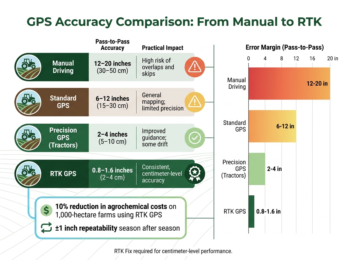
GPS Accuracy Comparison: Standard vs. RTK for Precision Agriculture
Better Accuracy and Efficiency in Field Applications
RTK GPS technology offers pinpoint precision, narrowing equipment location accuracy down to 2–4 cm. This eliminates the overlaps and skips often seen with standard GPS systems. For example, on a 1,000-hectare (about 2,470-acre) farm, this level of accuracy can reduce agrochemical costs by as much as 10%.
| System Type | Pass-to-Pass Accuracy | Practical Impact |
|---|---|---|
| Manual Driving | 12–20 inches (30–50 cm) | High risk of overlaps and skips |
| Standard GPS | 6–12 inches (15–30 cm) | General mapping; limited precision |
| Precision GPS (Tractors) | 2–4 inches (5–10 cm) | Improved guidance; some drift |
| RTK GPS | 0.8–1.6 inches (2–4 cm) | Consistent, centimeter-level accuracy |
This level of precision not only improves efficiency but also supports safer operations and ensures compliance with agricultural regulations.
Safety and Compliance
RTK GPS isn't just about efficiency - it also plays a crucial role in improving safety and meeting regulatory standards. By keeping equipment on precise, pre-set paths with sub-inch accuracy, it becomes especially useful in challenging conditions like early morning fog, dusty harvests, or nighttime work. Operators can trust the system to guide them safely and reliably.
Additionally, RTK GPS helps prevent chemical drift into sensitive areas, such as conservation zones, drainage ditches, or neighboring properties. With boundary accuracy down to an inch, equipment stops exactly where it should. This precision not only protects the environment but also ensures compliance with USDA programs and state pesticide regulations. Integrated auto-steering features further reduce operator fatigue during long workdays, allowing more focus on equipment performance and field conditions.
Long-Term Benefits for Farm Operations
RTK GPS systems offer consistent mapping capabilities, creating a reliable field record that can be used year after year. These systems provide season-to-season repeatability within ±1 inch. Over time, RTK-mapped boundaries become a standardized reference for your fields, ensuring that all equipment - from tractors to harvesters - operates using the same precise data.
This consistency simplifies team coordination, minimizes errors when training new operators, and supports advanced farming methods like controlled-traffic farming. It also makes inter-row cultivation more reliable, contributing to smoother and more efficient farm operations in the long run.
Getting Started with RTK GPS on Your Farm
Equipment and Setup Requirements
Setting up RTK GPS on your farm doesn’t have to be complicated. You’ll need an RTK receiver paired with a GNSS antenna, a correction signal receiver, and a compatible in-cab display. Common displays like the John Deere G5 or GreenStar work seamlessly with RTK receivers to handle offset corrections and record field boundaries.
For correction signals, you’ve got two main choices: setting up a local base station or using a CORS/NTRIP network via a 4G/LTE connection. If you’re new to RTK, network-based RTK (NTRIP) is often the easiest option since it doesn’t require base station hardware. Just make sure your fields have reliable cellular coverage before relying on this method.
Proper antenna placement is key. Mount the GNSS antenna vertically, about 5–6 feet (1.5–2 meters) high, and position it at the center of your vehicle’s roof. The antenna needs a clear, unobstructed view of the sky to function effectively. Avoid placing it near metal structures, tree lines, or buildings, as these can interfere with the signal. Before you start mapping, double-check that your display shows an "RTK Fix" status.
Once everything is set up and your RTK Fix is confirmed, you’re ready to move on to mapping with precision.
Best Practices for Accurate Mapping
To ensure your boundary data is as accurate as possible, follow these guidelines. Always map under open skies - stay away from tree lines, buildings, or grain bins that could cause signal issues. Enable all available satellite systems, including GPS, GLONASS, Galileo, and BeiDou, to maintain consistent accuracy.
Stay within 18–19 miles (around 30 kilometers) of your base station or NTRIP reference point, as accuracy drops significantly beyond this range. If you’re mapping on foot, keep the antenna pole upright and walk steadily along the true field edge - not along a fence or road unless they define the boundary. Use your mapping software’s "Pause" feature to navigate obstacles like utility poles or washouts. When you resume, the software will automatically create a straight line across the gap, keeping your data clean.
"RTK shows the actual area and records every turn of the boundaries... there won't be any conflicts with neighbors." - RTK-Navigation
Re-map your boundaries whenever there’s a major change to the land, such as after installing tile drainage, removing fences, or acquiring new property. This keeps your records accurate and up to date.
Using RTK Data in HarvestYield
Once your fields are mapped with precision, you can integrate the RTK data into HarvestYield for better job management. HarvestYield allows you to save RTK-mapped boundaries and link them directly to job records. This means that tasks like spraying, planting, or harvesting are tied to precisely measured field areas instead of rough estimates.
After completing a job, HarvestYield logs GPS data and weather conditions, creating a detailed, timestamped record of field activity. Because the boundaries are mapped with centimeter-level accuracy, the platform’s tools provide exact measurements for the area worked. This precision improves input tracking for items like seeds, fertilizers, and chemicals. It also simplifies billing for contractors who charge by the acre. For farm managers, the platform’s team visibility features ensure everyone is working from the same verified data, reducing miscommunication and avoiding duplicate entries throughout the season.
Conclusion
Key Benefits of RTK GPS for Farmers
RTK GPS has revolutionized field mapping. While standard GPS systems can veer off by 10–16 feet, RTK GPS narrows that margin to under 1.2 inches. This level of accuracy helps farmers minimize waste, improve field recordkeeping, and maintain consistent, precise field boundaries.
With ±1 inch repeatability, farmers can return to the same rows and guidance lines year after year. This reduces overlaps during planting and spraying, saving on seeds, chemicals, and fuel. For instance, data shows that accurate boundary mapping on larger farms can lower agrochemical costs by as much as 10% through more precise applications.
One farm manager shared their experience:
"Yes, we invested in the equipment. But now we are no longer dependent on someone else's schedule and we don't pay for every single point. We control our land ourselves." - Farm Manager, 11,000-hectare operation
These benefits make RTK GPS an essential tool for farmers looking to embrace precision agriculture.
Next Steps for Precision Agriculture
The operational advantages of RTK GPS directly translate into cost savings and improved efficiency. Farmers should consider whether a local base station or a network RTK (NTRIP) connection suits their needs. For most, NTRIP offers a straightforward solution, requiring only a reliable cellular connection and an RTK-capable receiver - no additional hardware needed.
To maximize the benefits, integrate RTK-mapped boundaries with HarvestYield. This ensures every farming task, from spraying to harvesting, is tied to GPS-verified acreage, streamlining operations and enhancing productivity. This includes using GPS navigation for farm fields to ensure operators find the correct entrances without delay.
FAQs
Do I need my own RTK base station, or can I use NTRIP?
With NTRIP (Networked Transport of RTCM via Internet Protocol), you can skip the hassle of setting up your own RTK base station. Instead, your RTK GNSS receiver connects to an NTRIP service through the internet - using either cellular or Wi-Fi. This service provides correction data from a network of permanent reference stations, enabling you to achieve centimeter-level accuracy for tasks like boundary mapping, all without the expense or upkeep of a local base station.
How can I confirm my receiver has RTK Fix (not Float) before mapping?
To verify an RTK Fix, look at your device interface for the current status. At first, the receiver might display RTK Float, which means corrections are being applied but ambiguities remain unresolved. Be patient and wait until the status changes to RTK Fixed. This indicates that integer ambiguities have been resolved, achieving centimeter-level accuracy. Begin mapping only after the Fixed status appears to ensure precise boundary measurements.
Will NAD83 to NATRF2022 changes shift my saved field boundaries and A-B lines?
Switching from NAD83 to NATRF2022 will cause shifts in your saved field boundaries and A-B lines. This happens because the new datum adjusts for discrepancies in the Earth's center, leading to horizontal shifts ranging from about 1 to 4 feet, depending on your location.
If you rely on RTK base stations or networks that are tied to NAD83, it’s essential to check with your equipment dealer about necessary updates. Additionally, tools like NCAT (National Coordinate Transformation Tool) can help with transforming your data to align with the new datum.
Platforms like HarvestYield can simplify this process by centralizing and managing these updates, ensuring your data stays accurate and organized.