Weather Data vs. GPS: Why Both Matter for Farms
Farming today depends on precision tools to boost efficiency and reduce waste. Two key technologies - weather data and GPS tracking for farm equipment - help farmers make better decisions. Weather data focuses on when to act, like planting or spraying, while GPS ensures where and how to work, minimizing overlaps and saving resources.
Key Takeaways:
- Weather Data: Guides timing for planting, irrigation, and pest control. Helps reduce crop losses by up to 20% and input costs by 10–25%.
- GPS Tracking: Provides precise field mapping and machinery guidance. Cuts fuel use by 15%, reduces fertilizer waste by 20%, and improves yields by 5–10%.
- Combined Benefits: Together, these tools improve decision-making, prevent resource waste, and increase productivity.
Quick Comparison:
| Feature | Weather Data | GPS Tracking |
|---|---|---|
| Primary Use | Timing operations | Precision in fieldwork |
| Cost Savings | Cuts irrigation and input waste | Reduces fuel, labor, and overlaps |
| Limitations | Needs local stations for accuracy | Signal disruptions near obstacles |
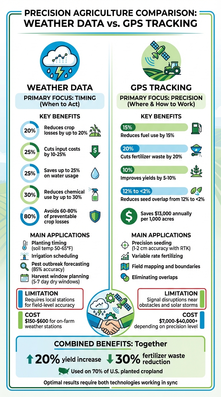
Weather Data vs GPS Tracking in Precision Agriculture: Key Benefits and Cost Savings
Precision Agriculture: How to Use Weather Forecast Data to Inform Your Crop Management
Transform Your Agricultural Team
Streamline job management, field mapping, and machine tracking with HarvestYield. Simplify your operations and eliminate paper job sheets.
ContinueHow Weather Data Supports Farm Management
Weather data is transforming how farmers manage their fields, allowing for precise timing of operations that can boost yields by up to 20% and cut costs by 10-25%. Instead of relying on guesswork or regional forecasts that might be miles off, farmers now depend on field-specific weather insights to guide everything from planting to harvest.
The real game-changer is proactive planning. Early warning systems can help avoid 60-80% of preventable crop losses by identifying risks before they become problems. For example, real-time data on wind conditions can ensure pesticides are applied effectively, while evapotranspiration rates guide smarter irrigation schedules. It’s all about turning weather conditions into actionable decisions.
"You can't rely on the weather 20 miles away when making decisions for your own field. A cloud burst or a windy hour can be the difference between a successful application and a wasted one." - Bryce Sutherland, Crop Advisor, Ag Shots LLC
The move to hyperlocal forecasting has been a huge leap forward. On-farm weather stations and GPS-coordinated forecasts capture microclimate differences that regional data misses. A single farm might have varying humidity or wind patterns just a few hundred yards apart - details that could make or break critical decisions like irrigation or pesticide application.
Scheduling Planting, Irrigation, and Harvesting
Accurate scheduling, powered by real-time weather data, is a cornerstone of modern farming. For planting, soil temperature monitoring ensures seeds germinate under optimal conditions - spring crops, for instance, need soil temperatures between 50-65°F to thrive. Farmers also use Growing Degree Days (GDD) to predict crop maturity within a 3-5 day window.
When it comes to irrigation, weather data eliminates unnecessary water use. By checking forecasts, farmers can skip watering if there’s a 40% or higher chance of rain in the next 24-48 hours. This practice, combined with monitoring evapotranspiration rates, can save up to 25% on water usage. It also helps prevent nutrient leaching, which occurs when excess water washes fertilizers below the root zone.
Harvesting, too, benefits from precise planning. Farmers look for 5-7 day dry windows with low humidity and favorable winds to maintain crop quality and avoid spoilage. Proper timing not only preserves yield but also reduces fuel costs by up to 15%, as working in wet conditions often increases soil compaction and equipment wear.
Forecasting Pest Outbreaks and Extreme Weather
Weather data is also a powerful tool for pest management. With weather-based pest models achieving up to 85% accuracy, farmers can shift from reactive to preventative strategies. For instance, high humidity above 80% creates ideal conditions for fungal diseases like blight, while warm temperatures speed up insect reproduction cycles for pests such as aphids.
Using GDD calculations, farmers can pinpoint when pests will reach critical stages, avoiding the inefficiencies of calendar-based spraying schedules. This precision reduces chemical use by up to 30% while maintaining effective protection. Weather data also ensures safer and more efficient pesticide application - farmers avoid spraying when wind speeds exceed 10-15 mph, preventing drift and ensuring the product hits its target.
Extreme weather warnings provide another layer of protection. Frost alerts or heatwave warnings can trigger automated irrigation or prompt schedule adjustments, while heavy rain forecasts allow farmers to accelerate harvests, reducing weather-related losses by 15-20%.
Using Historical Weather Patterns
Historical weather records are essential for long-term farm planning. By analyzing 30+ years of temperature and rainfall data, farmers can match crops to their local climate and identify unique conditions on their land, such as frost-prone areas or poorly draining spots. Historical frost dates, for example, guide planting schedules to balance early growth with frost risk.
However, climate change is complicating this process. Spring thaws now occur up to 20 days earlier in many temperate regions, making historical patterns less reliable. To adapt, farmers combine historical data with current climate models, refining their strategies. Comparing past yields with weather trends over 10-20 years helps identify the best conditions for success and highlights outliers caused by extreme events. These insights allow farmers to turn long-term trends into actionable, field-level decisions.
| Planning Horizon | Data Type | Primary Agricultural Application |
|---|---|---|
| Long-term (Years) | Historical Climate Trends | Crop selection, infrastructure planning |
| Medium-term (1-6 Months) | Seasonal Forecasts | Rotation planning, variety selection |
| Short-term (0-10 Days) | Tactical Forecasts | Irrigation scheduling, spraying, harvest timing |
How GPS Tracking Supports Farm Management
GPS tracking has become a cornerstone of modern farming, transforming machinery into precision tools that improve accuracy and efficiency across agricultural operations. While weather data helps farmers decide when to work, GPS technology pinpoints where and how to work - delivering measurable improvements in productivity and cost savings.
Farms using GPS guidance systems report significant benefits, including fuel savings of 10–15% and reductions in fertilizer and pesticide use by up to 20%. On a typical 1,000-acre farm, this translates to approximately $13,000 in annual savings on variable costs through GPS guidance alone. As of 2019, more than 50% of acres planted with major crops like corn and soybeans utilized auto-steer systems, and GPS technology was deployed on 40% of U.S. farm and ranch acreage.
"GPS guidance is not just a convenience; it is a measurable advantage that turns into real profit margins for farmers." - Deborah Young, Agricultural Technology Author
The technology has advanced rapidly. Standard GPS provides accuracy within 20–30 cm (about 8–12 inches), which is sufficient for basic tasks. However, for high-precision operations like strip-tilling or inter-row planting, RTK (Real-Time Kinematic) GPS offers accuracy within 1–2 cm (roughly 0.4–0.8 inches).
Precision Seeding and Fertilizing
Variable Rate Technology (VRT) takes precision to the next level by adjusting seed and fertilizer application rates in real time based on management zones. These zones are defined using factors like soil type, moisture levels, and past yield data. Compared to traditional uniform seeding, VRT can boost crop yields by up to 20%. On average, GPS-guided systems increase yields by 5–10% per acre, with corn yields rising from 162 bushels per acre to 175 bushels - an 8% improvement. Additionally, precision guidance reduces nitrogen runoff by 30%, promoting better soil and water quality.
Auto-steering systems also play a key role, ensuring consistent row spacing and reducing operator fatigue. These systems allow farmers to work efficiently under challenging conditions, such as low visibility caused by fog, dust, or nighttime operations. The level of GPS accuracy required depends on the task. For example, basic tillage can use standard GPS, while planting and strip-tilling benefit from the centimeter-level precision of RTK. Sub-meter accuracy (approximately 0.2–1 meter) is often sufficient for fertilizing, but higher precision is crucial for row-by-row operations, ensuring repeatability essential for controlled traffic farming.
Eliminating Overlap and Saving Resources
Field overlap during operations can be costly. Traditional methods often result in seed overlap rates of around 12%, but GPS guidance reduces this to less than 2%, an improvement of roughly 80%. Similarly, fertilizer waste drops from 18% to between 4% and 6% with GPS systems. Automatic section control further optimizes efficiency by shutting off sprayer or planter sections in treated areas, preventing over-application.
The resource savings add up quickly. GPS guidance cuts fuel consumption per acre from 4.2 liters (about 1.1 gallons) to 3.6 liters (nearly 1 gallon) - a 15% reduction. Labor efficiency improves by 25%, reducing the time required to work 100 acres from 10 hours to 7.5 hours. These efficiencies allow farmers to cover more ground in less time, which is critical during tight planting or harvest windows.
Entry-level GPS systems start at around $7,000, while mid-range options for medium-sized farms range from $10,000 to $25,000. High-end systems with features like full auto-steering, RTK, and yield mapping can exceed $40,000. Many systems can also be retrofitted onto older tractors, enabling farmers to upgrade without replacing their entire fleet.
Field Mapping and Resource Planning
Accurate field mapping is essential for effective resource management. GPS technology creates digital boundaries with centimeter-level precision, eliminating guesswork. Traditional acreage estimates can vary by 5–15%, but GPS mapping reduces boundary errors by about 20%. Knowing the exact size of each field allows for precise input ordering, better equipment scheduling, and more accurate yield projections.
Field maps do more than define boundaries - they also capture critical variations, such as elevation changes, drainage patterns, and soil differences, which influence productivity. This data supports the creation of management zones for Variable Rate Technology, ensuring that each area receives the right amount of inputs.
Digital mapping also simplifies logistics and compliance. Automated records with timestamps replace paper logs, proving invaluable for crop insurance claims, regulatory reporting, and performance analysis. Farmers can also use these maps to calculate exact seed and fertilizer needs, reducing over-ordering and storage costs. Additionally, improved maps streamline equipment scheduling and guide long-term decisions, such as infrastructure investments, based on verified field layouts.
The growing adoption of GPS technology highlights its value. Over the past 20 years, U.S. corn farms have seen an average annual growth rate of 19% in guidance system use. By 2025, more than 70% of large farms worldwide are expected to rely on GPS-guided machinery. As costs decrease and accuracy improves, even smaller farms are finding these systems worthwhile, setting the stage for understanding how GPS tracking complements weather data in modern agriculture.
Weather Data vs. GPS: Strengths and Weaknesses
Weather data and GPS tracking play distinct yet complementary roles in farm management. Each addresses different aspects of decision-making: weather data focuses on when to act, guiding decisions like planting, spraying, or harvesting based on forecasts and historical trends. On the other hand, GPS tracking zeroes in on where and how to act, ensuring precision and minimizing waste. Together, they tackle two of farming's biggest challenges. Weather accounts for up to 70% of the uncontrolled risks farmers face, while GPS-guided equipment is now used on 70% of all planted U.S. cropland. By examining their strengths and weaknesses side by side, farmers can better understand how to use these tools effectively.
However, neither technology is flawless when used on its own. Weather data, for instance, struggles with spatial variability. Regional forecasts, often sourced from airports or distant stations, may miss field-specific conditions. Precipitation can differ by nearly 1 inch between sensors just a mile apart. Additionally, climate change is making historical weather patterns less reliable. Achieving precise, actionable data often requires installing on-field weather stations, which can cost anywhere from $150 to $600.
GPS tracking, while highly effective, has its own set of challenges. Signal drift can occur near obstacles like trees or hills, and solar flares or geomagnetic storms can disrupt accuracy. These disruptions can shift precision from mere inches to several feet or even cause total signal loss. A severe solar storm predicted for 2025 could impact up to 40% of GPS-guided farm equipment worldwide. For farmers in Illinois, such outages during critical planting periods could lead to revenue losses of $90 per acre if planting is delayed from early to late May.
Comparison Table
| Feature | Weather Data | GPS Tracking |
|---|---|---|
| Primary Use | Timing (when to plant, spray, or harvest) | Precision (where to drive and apply inputs) |
| Decision Accuracy | Predictive; relies on models and sensors | Spatial; relies on satellite signals and RTK |
| Cost Impact | Cuts crop loss and irrigation waste by 10–25% | Reduces fuel, labor, and input overlap by 10–20% |
| Implementation | Requires station maintenance and data interpretation | Requires setting field boundaries or in-cab displays |
| Key Limitation | High spatial variability; regional forecasts may lack field-level detail | Signal drift near obstacles; vulnerable to solar storms |
| Hardware Cost | $150–$600 for basic on-farm weather stations | Varies depending on precision requirements |
The synergy between these technologies is undeniable. GPS ensures machinery operates with precision, while weather data provides the insights needed to act at the right time. For example, GPS can prevent overlapping spray rows, but weather data might indicate that high wind speeds make spraying inadvisable due to drift risks. Recognizing how these tools complement each other is the first step toward integrating them for better farm management.
HarvestYield's Integration of Weather Data with GPS Tracking
HarvestYield combines the power of weather data and GPS tracking into a single, streamlined platform designed specifically for agricultural teams. Instead of juggling multiple tools, farm managers, contractors, and small farm owners can access everything they need through one centralized dashboard. This system links real-time weather updates and forecasts directly to job scheduling, making it easier to pinpoint the best times for planting, spraying, or harvesting. If the weather shifts unexpectedly, the platform automatically updates schedules and sends out revised digital job sheets to operators. This seamless integration also supports advanced field mapping features.
The field mapping tools showcase how weather and GPS data can work hand-in-hand. Users can map out field boundaries by simply tracing the perimeter with their smartphone. The system then calculates the acreage, making it easier to allocate resources like seeds and fertilizers efficiently. By combining GPS-based mapping with highly localized weather data, HarvestYield delivers microclimate insights for individual fields. This allows farmers to track which areas perform best under specific conditions. Over time, these insights help guide decisions on crop varieties and farming practices that align with each field's unique conditions and historical trends.
Another standout feature is the automation of digital record keeping, which eliminates the hassle of managing paper job sheets. GPS tracking automatically logs weather conditions, timestamps, and coverage paths for each job - no manual input required. This not only reduces errors but also gives farm managers a clear view of operations. Managers can even create operator accounts to assign jobs and receive electronic timesheets and job records automatically.
The integration is particularly useful for irrigation and pest management. GPS technology allows for precise water application to specific areas of a field, while weather forecasts help avoid unnecessary irrigation by factoring in predicted rainfall. For pest control, GPS mapping tracks where outbreaks have occurred in past seasons. When this data is paired with current weather conditions, farmers can predict which zones are most at risk and apply treatments only where needed. This targeted approach not only lowers costs but also reduces the environmental impact by minimizing pesticide use.
Additionally, GPS tracking provides turn-by-turn navigation, including details like access points and potential hazards. Combined with real-time weather alerts, this ensures teams can respond quickly to changing conditions while keeping accurate operational records for compliance and future planning.
Benefits of Combining Weather Data and GPS
Bringing weather data and GPS together creates a powerful combination that surpasses the capabilities of either technology on its own. Take Variable Rate Application (VRA), for instance. With GPS-mapped zones, farmers can precisely determine where to place seeds, fertilizers, and pesticides. When paired with weather insights - like Growing Degree Days (GDD) and soil moisture levels - this system fine-tunes input requirements. The results are impressive: fertilizer waste drops by up to 30%, input costs decrease by 10–25%, and crop yields improve by as much as 20%. This integration doesn’t just optimize resource use - it also lays the groundwork for real-time operational alerts.
Real-time alerts are a game-changer during critical tasks. For example, during spray applications, GPS ensures every part of the field is covered, while weather data helps decide if it’s the right time to spray. By setting up mobile alerts for wind speeds above 10–15 mph, operators can pause GPS-guided spraying to prevent chemical drift, avoiding off-target applications. This seamless communication between weather data and GPS keeps operations efficient and precise.
Precision irrigation is another standout example of this synergy. GPS-linked systems deliver water to specific field zones, while weather factors like temperature, humidity, and wind determine how much water is needed. If rain is forecasted within the next 24–48 hours, farmers can skip irrigation, saving water and reducing nutrient runoff. This approach doesn’t just conserve resources - it also cuts fuel use, lowering consumption from about 2.7 gallons per acre to 1.9 gallons per acre. Field coverage accuracy leaps from 85% to over 98%. Precision irrigation highlights how integrating data improves both resource efficiency and operational timing.
Timing is critical, and this integration takes it to the next level. GPS-linked temperature sensors combined with GDD calculations can pinpoint harvest windows within 3–5 days, ensuring peak crop quality and minimizing losses. Consider tomatoes: temperature swings during flowering can reduce fruit set by up to 40%, making accurate, field-specific monitoring essential. By merging GDD data with precise mapping, farmers can make both immediate and long-term decisions based on reliable, actionable insights.
Conclusion
Weather data and GPS tracking each play a crucial role in modern farm management. Weather data helps farmers decide when to plant, spray, or irrigate by providing insights into temperature, humidity, and wind conditions. On the other hand, GPS tracking focuses on the where, ensuring precision in field operations, reducing overlaps, and accurately mapping input applications. While each technology is powerful on its own, their combined use creates a system that drives efficiency and profitability.
Let’s look at the numbers: GPS-guided tractors can cut fertilizer overlap by 10–15%, while Variable Rate Application can reduce input costs by up to 25%. Precision farming techniques, powered by these technologies, have been shown to increase yields by as much as 20%. By 2019, GPS systems were already in use on 40% of U.S. farm and ranch acreage, and their adoption continues to expand as more farmers recognize their potential.
The integration of GPS precision with field-specific data eliminates guesswork, replacing it with actionable insights. This approach ensures decisions are based on accurate, real-time information rather than relying on generalized data from distant weather stations or imprecise fieldwork.
HarvestYield combines the strengths of weather data and GPS tracking to automate job recording and promote efficient resource management. By doing so, it enhances daily operations while supporting long-term profitability. Together, these tools enable farmers to manage their fields with precision, turning farming into a proactive and highly productive endeavor.
FAQs
Do I need an on-farm weather station or is a forecast enough?
General weather forecasts can help with broader planning, like deciding when to plant or harvest. However, they often fall short when precision is key, such as determining the right time for applying pesticides or managing irrigation. This is where on-farm weather stations come in. These stations deliver real-time, field-specific data - like temperature, humidity, and rainfall - providing the detailed insights you need to make smarter decisions and minimize risks, particularly in regions with microclimates.
What GPS accuracy do I need for planting versus spraying?
When it comes to planting, a GPS accuracy of 4–10 centimeters is generally enough to achieve precise seed placement. For spraying tasks, an accuracy of about 30 centimeters (submeter level) works well to minimize overlaps and ensure consistent application. Selecting the appropriate level of accuracy is key to boosting efficiency and cutting down on waste.
How do I use weather and GPS together to reduce inputs?
Combining weather data with GPS technology allows for more precise use of resources in agriculture. GPS systems map fields and highlight variations within them, enabling farmers to apply inputs like water, fertilizer, or pesticides exactly where they’re needed. Meanwhile, weather metrics - such as humidity, temperature, and wind speed - help determine the best timing for tasks like irrigation and fertilization. This approach not only cuts down on waste and lowers costs but also helps reduce the impact on the environment.
Tools like HarvestYield bring these elements together, offering farmers a streamlined way to make decisions that enhance both crop health and overall yield.